Apps (iPhone, iPad & iPod):
![]() great white shark
great white shark
![]() sharks
sharks
![]() seabirds
seabirds
Scientific shark articles
Alaska & Wildlife
Arctis
Birds
Cities
Egypt - Land of the Nile
Fauna & Flora Fiji
Fiji sharkproject
Mountains
Nature
Penguins & seals
Polar bear
Sea
Seabirds
Sharks
Southern Right Whale
Underwater
Wildlife South Africa
On the left the North Breakwater and the North Headland with the Manitowoc 4600 can be seen. On the right side you can see the South Breakwater. (00092002)
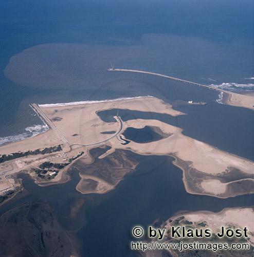
| Description: | Richards Bay Harbour/Natal/South Africa Aerial view of the harbour expansion Richards Bay with the lagoon Before work began on the great harbour on the east coast of the Republic of South Africa in the province of Natal, the beautiful lagoon of Richards Bay was a secret tip for a few fishers. The lagoon had a length of about 7 km and a width of 5 km and an area of 3050 ha. Also, all around, the nature was completely intact with an exceedingly species-rich fauna and flora. For the harbour expansion half of the entire area of the natural lagoon was needed. By means of a 4.5 kilometer dike, which divides the harbour from the lagoon, the part of the lagoon, which was not needed, was to remain as a nature reserve. The dike was equipped with a flood regulator, which regulates the water level in the remaining lagoon and at the same time uses the high water of the river flowing into the lagoon to flush the harbour. The harbour Richards Bay lies in a natural lagoon, which was dredged to a water depth of 23 m. Two breakwaters – the southern at a length of 1.4 kilometer and the northern at a length of 600 m including the north headland with 480 m, offer protection from the strong all-year-round sea motion of the Indian Ocean. The most important single structures are the two large quay walls for the docking of ships. Each one is 800m long and 30 meters high. On one of the quay walls (coal quay) South African coal is loaded for export (water depth of 23 m, head height of + 5.2 m). The second quay wall (general cargo and mass quay) is designated for general cargo (water depth of – 23 m, head height of + 5.2 m). The harbour basin in the lagoon was dredged to – 19 m. The harbour access channel from the sea side was dredged at a width of approx. 300 m and a length of approx. 7 kilometers to a water depth of 19.50 to 24.0 meters. |